
-
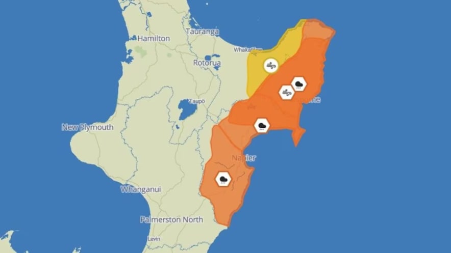
MetService has issued heavy orange rain warnings for Gisborne and Hawke’s Bay on Tuesday and Wednesday.
-
Residents are advised to prepare for potential rapid rises in water levels and hazardous driving conditions.
-
Severe gales with speeds up to 120km/h are expected, particularly affecting coastal areas.
-
Weather could continue into Thursday. Civil Defence “keeping a close watch” on the situation.
Orange heavy rain and strong wind warnings are in place for the Gisborne region today and into tomorrow.
The heavy rain warning for Gisborne/Tairāwhiti and south of Ruatoria runs through to midday tomorrow, with 140mm-180mm of rain inland and 100m-150mm about the coast with peak rates of 15mm/hr-25mm/hr this afternoon and evening.
“That’s some heavy rain out there whānau,” Tairāwhiti Civil Defence said on social media this morning.
“We’ve been here before and we know what to do.
“Limit unnecessary travel. We’ve got the TEMO (Tairawhiti Emergency Management Office) team keeping a close eye on things and will update the community as soon as we can.
"Stay safe.”
A heavy swell has been issued by MetService too, with combined wave size from the southeast rising to five metres this afternoon and 5.5 to 6 metres tonight.
Niwa said this morning that its concerns were growing for a significant rain event, associated with a storm approaching the east coast.
Multiple warnings were issued from Tuesday morning for Hawke’s Bay and Gisborne as both regions prepared for a lashing of “severe” gales and heavy rain.
An orange heavy rain warning is in place for 36 hours from 9am Tuesday until 9pm Wednesday for Hawke’s Bay north of State Highway 5 to Gisborne and south of Tolaga Bay.
An orange strong wind warning will also take effect for 18 hours from 12pm Tuesday until 6am Wednesday for Gisborne and Hawke’s Bay from Wairoa north, including Māhia Peninsula.
Severe gales are expected, with southerlies gusting 120km/h in exposed places. Most of the extreme wind is expected to be felt in coastal areas.
MetService meteorologists indicated the slight potential for the warnings to escalate to a red warning and also warned of the possibility of further rain from Wednesday night into Thursday.
Streams and rivers could rise rapidly, and surface flooding, slips, and difficult driving conditions were also possible.
MetService advised residents to clear their drains and gutters, avoid low-lying areas and drive cautiously.
Hawke’s Bay Regional Council said crews were working to open the Wairoa River mouth for low tide on Wednesday, moving it from the western end of the Whakamahi Lagoon closer to the Eastern Ngatmotu Lagoon.
working to open the Wairoa River mouth for low-tide on Wednesday, moving it from the western end of the Whakamahi Lagoon closer to the Eastern Ngatmotu Lagoon.
Deep low-pressure system to stick around
MetService said peak intensities of rain would range from 10 to 15mm/h and could be expected from Tuesday afternoon until before dawn on Wednesday, with surface flooding and slips a possibility.
“We’ve got a deep low pressure system northeast of the North Island today, and we’re expecting it to stick around for the next few days,” MetService meteorologist Ngaire Wotherspoon said.
“Tuesday and Wednesday are when we are expecting the heaviest rain and strongest winds to make their way to the eastern areas of the North Island.”
MetService advised through social media that an extended period of strong winds will mean dangerous coastal conditions along the East Coast. People could continue following the MetService website for further weather and warning updates.


0 comment
JOIN THE CONVERSATION
Read and post comments with a
Newsroom Pro subscription.
Subscribe now to start a free
28-day trial.